Thursday, October 11, 2012

Damp and leafy, but at least there's parking

The parking lot at Hurd Field in Arlington Heights is open again after months of reconstruction with porous paving that reduces runoff. The lot will stay open while a few project details are finished up.

The Hurd Field ramp leading to the lot

The porous pavement is coarse and open

There haven't been clear markings for years

Porous pavement project info at the northeast corner

Wednesday, August 29, 2012

Guest Appearance: The Route 390 Trail

My wife and I took a walk from our hotel on Sunday morning and unexpectedly found ourselves at the southern end of the Route 390 Trail. The trail starts at the interchange of an interstate highway with a heavily traveled, divided, six-lane commercial road (Ridge Road West), but immediately drops below street and highway level into dense woods along a pond. We saw a rabbit on the trail, ducks and herons on the water. It was wonderful and surprising.

Checking a map later, we learned that the trail runs about five miles north from where we started, nearly to Lake Ontario, to meet the Lake Ontario State Parkway Multi-Use Trail. We had unknowingly seen a different section of it the day before, where it runs alongside a nursing home parking lot off Latta Road.

Friday, June 15, 2012

Going afoot

Each year I put off training for the JPMorgan Chase Corporate Challenge until about now and it's true again this year. What's different is that the run is July 12th instead of the usual late June and I'm really not too late. So I didn't skate this morning, but walked a brisk 3.5 miles from Hurd Field to Mill Street and back. Next week, a light jog.

Between Woburn Street and Fletcher Avenue, Lexington

Tuesday, June 12, 2012

On the road again

This morning I saw an outbound bicyclist with two young children in an open cargo bin toward the front of his bike. This afternoon one office-mate was telling another about the hazards of pedestrian life in Amsterdam, with their swarming, speeding cyclists. "And the kids just sit loose in these big baskets!" Sure enough, a little image-googling turns up a Dutch bicyle something very much like the one I saw.

Today's other unusual sight was a utility cover lifter in use near the Woburn Street Crossing. I'm sorry I didn't have my camera, as I can't find an on-line photo of a lifter with a counter-weighted handle such as this one seemed to have.

Most of the trail's root cracks and bumpy sections have been marked with white paint recently, mostly in little perpendicular stripes like Frankenstein's neck stitches. Some larger areas are marked by stenciled CAUTION BUMPS advisories. It looks like the cheapest possible approach to the problem short of outright neglect. And as the markings are the same through Arlington and Lexington, I'm guessing they weren't done by the towns, but unofficially.

Wednesday, April 25, 2012

Yet another closure

The heavy rain Sunday night into Monday was too much for an old culvert near Hartwell Avenue in Lexington. According to notices on the ABAC list, Arlington town announcements list, and Lexington news site, the trail will be closed for repairs from Bedford Street to Hartwell Avenue starting tomorrow (April 26th). "We will try to have to trail open for the weekend."

Update: Closure continues as of Monday, April 30th.

Tuesday, March 27, 2012

Bikeway cleanup, Saturday April 28th

Forwarded from the ABAC list:

Please join the Arlington Bicycle Advisory Committee in a spring cleanup of the Minuteman Bikeway in Arlington. The cleanup will take place on Saturday April 28 from 9:30am to 1:00pm. Steady rain in the morning will cancel the event.

We will be distributing trash bags at the three locations listed below but if there is a stretch of the path that you frequent and want clean and are willing to provide your own bags—go for it.

Arlington Heights, by the path by the Park Ave. Bridge.
Arlington Center, by the path at Water Street.
East Arlington, by the path at the Rt. 2 overpass near Thorndike Field.

Bring gloves if you have them. Trash bags will be provided at these three locations. For further information, contact Stephan Miller via email or by phone (781-641-2845).

Friday, March 23, 2012

Posted trail closings

East of Fottler Avenue toward Bow Street, signs were up today saying the trail would be closed from 3/22 (yesterday) through 4/6 (two weeks from today). Users are referred to http://www.lexingtonma.gov/dpw/constructionprojects.cfm for more information. West from Fottler, another sign says 3/26 (next Monday) through 4/6.

DPW workers were setting up near Bow Street at 7:40 this morning. Traffic flowed around them then, but was cut off and detoured soon after. The trail is supposed to be open on weekends, probably also outside working hours.

Today: 13 miles. This year: 80 miles.

Thursday, March 22, 2012

Milepost VII and other sights

The 'way was supposed to be all open today, with the closure west of Bedford Street re-opened and closure at Bow Street not starting 'til tomorrow. I took full advantage and made my first visit of the year to the Bedford end. Along the way I admired the many drainage improvements, toured the revised crossing of Westview, and saw a surprising number of road-killed frogs. For no reason I could think of, there were three dead frogs in a hundred yards or so behind the Waldorf School in Lexington.

Contrary to the announcement, Lexington DPW workers had already posted (but weren't enforcing) the closure near Bow Street by 8:30 this morning.

Milepost VII/IIII after flooding in 2010.


Milepost VII/IIII today

Westview Avenue is a square crossing now

Improved drainage near Tophet Swamp

Today: 13 miles. This year: 67 miles.

Wednesday, March 21, 2012

Construction, Closures, and Fine, Fine Weather

The Minuteman Trail will be closed between Bow Street and Fottler Avenue starting March 23rd for drainage work. Detour via Massachusetts Avenue. That's the only closure in Lexington, though the various cuts remain unpaved.

Since-finished construction across Revere Street, Lexington

Expiring closure across Bedford Street, Lexington

Sunrise behind The Bike Stop, Arlington

Today: 11.2 miles. This year: 54 miles.

Monday, March 12, 2012

Path, interrupted

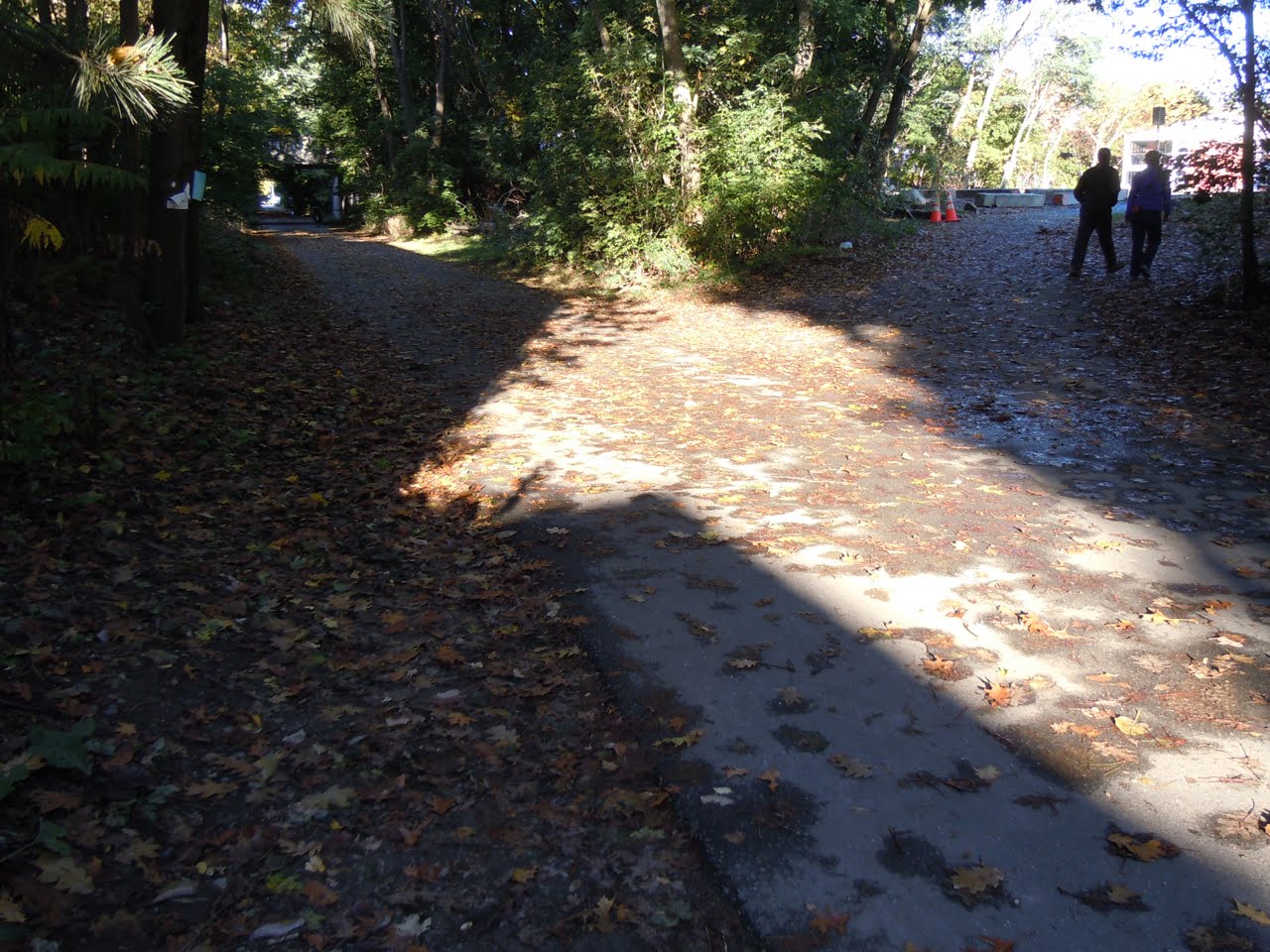
I did my first serious skating of 2012 in today's fabulous weather. West of Lexington Center, detour signs at Camelia Place are largely ignored because the trail is clear until just short of Revere Street. The culvert east of Revere is rebuilt, though the cut is filled with dirt and gravel for now. Heavy equipment west of Revere persuaded me not to cross.

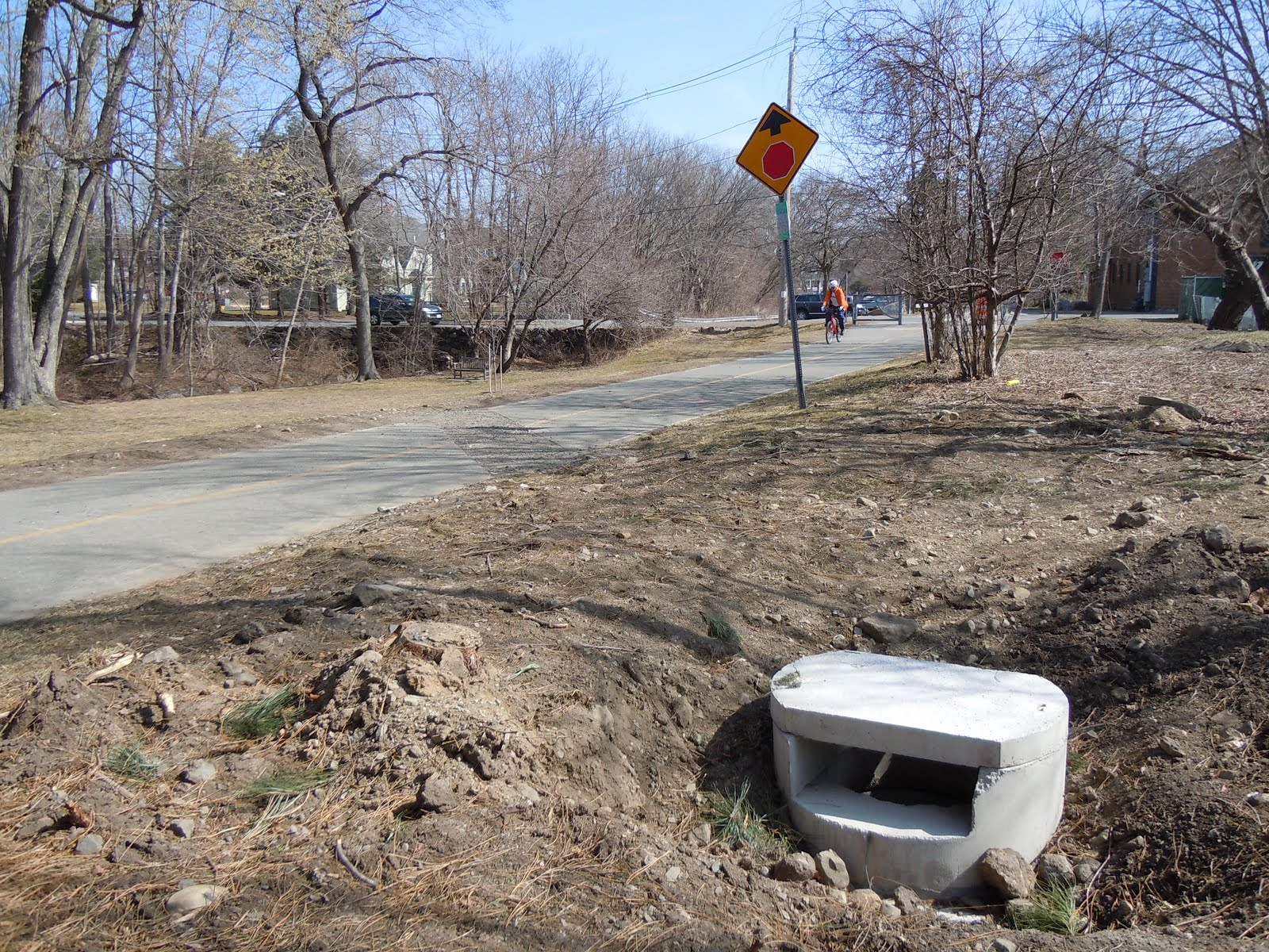
Two more culverts were replaced between Seasons Four and Maple Street, and another just west of Bow Street in East Lexington. None of these sites are repaved yet. I'm hoping they will be when the detour signage expires on the 16th. The Lexington DPW Projects page doesn't give an end date.

At Camelia Place, Lexington

West across Revere Street, Lexington

Maple Street in the distance

Near Bow Street, Lexington

Today: 6.4 miles. This year: 10.4 miles.

Monday, January 23, 2012

Construction this week

The trail will be closed from Seasons Four to Maple Street all this week, according to the Lexington DPW projects page.

Tuesday, January 10, 2012

Construction Ahead

Skating west from Lexington Center to 128 today, I noticed first that conditions are brilliant (for January), second that I ended 2011 with a very short brake pad, and third that there are half a dozen lines marked in fluorescent orange crossing the trail. Those last probably relate to some recent mail from Joey Glushko on the ABAC list, announcing drainage work on Minuteman Bikeway in Lexington. There might be partial or complete closures as work progresses near the Hartwell Avenue landfill (opposite Tophet Swamp), Revere Street, Bow Street, and Seasons Four. All these sections are troubled by flooding or debris following storms. There are often sand bars west of Bow Street, for example.

Today: 4 miles. This year: 4 miles.