Saturday, December 29, 2007

Google Street View

Google Maps Street View covers much of the Boston area now, including nearly all of Arlington and much of Lexington. A Google LatLong Blog post explains how to embed street views in other web pages, so here we go. The location is the Bow Street crossing of the bikeway in East Lexington.


View Larger Map

Thursday, December 27, 2007

Plowing + Melting = Clearing, Pretty Much

Some natural melting coupled with Arlington's plowing has made the trail much clearer. In Arlington Heights the trail averages nearly two-thirds of its full width, with some icy spots. A December 16th news item on Clear the Trail mentions the trail being plowed past the Arlington line to Bow Street in Lexington. That must have been for one storm only, as the latest plowing stops abruptly behind Mal's. From there to Bow Street it's solid ice.

Looking toward Bow Street from Drake Road

Thursday, December 20, 2007

I Took Pictures

I recently discovered that all the pictures I uploaded for this blog were accumulating into a Picasa web album. Now that I know, I've made the album public, captioned the photos, and made the whole mess searchable through Google Images. I'd link the photos back to their blog entries if I could, but Picasa Web Album captions seem to be straight text.

Tuesday, December 18, 2007

Then What Happened?

It got cold. It rained. I was tired. I was busy. My mother was visiting. I had stuff to do at the office. The dog ate my homework. Bottom line, I stopped skating in late October and now it's too late.

Arlington is plowing the trail this year as an experiment and it's working about as well as I expected, which is very poorly. Many entrances are blocked by snow and runoff forms patches of black ice on the trail. Plowing prevents skiing or snowshoeing on the path, but doesn't make it walkable.

At Hurd Field, Arlington

Behind Trader Joe's, Arlington
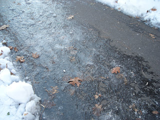
Check out the frozen footprints.

This year: 1439.5 miles. The End.